Previous Page - Next Page
Rock Corral Recreation Area
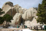 The Rock Corral Recreation Area is located on the west side of the Mineral Mountain Range. Towering from the desert floor are spectacular granite peaks and enormous standing rocks with Granite Peak being the most notable feature in the area. Granite Peak rises 9,771 feet above sea level and has several times been proposed to be set aside as a wilderness area. The Rock Corral Recreation area provides a variety of recreational opportunities such as hiking, picnicking, primitive camping, rockclimbing, horseback riding, rockhounding and more.
Floating The Provo River
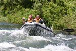 Most Utahan's are very familiar with the Provo River. One of Utah's blue ribbon fisheries well known for its beautiful Brown Trout. But have you ever thought about taking a float trip down the Provo? Well fortunate for Utah Outdoor Activities we were invited by High Country Rafting to experience a two hour adventure down the Provo River. Our adventure began at the High Country Rafting headquarters just 1/4 mile below Vivian Park.
Ogden's George S. Eccles Dinosaur Park
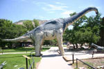 The George S. Eccles Dinosaur Park is an eight-acre park featuring realistic full-sized dinosaur sculptures enhanced with sound, robotics and artistic details that resemble the real thing. As you enter the park your adventure begins in the Elizabeth Dee Shaw Stewart Museum, which features some of the latest dinosaur finds in Utah and from around the world. The museum includes full-size dinosaur skeletons, real dinosaur bones, teeth, and many other educational exhibits. The paved trail system throughout the park takes visitors up close and personal to over one hundred life-size replicas of dinosaurs.
Red Ledges Picnic Area - Diamond Fork Canyon
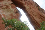 The Red Ledges Picnic Area is located up Diamond Fork Canyon. This picnic area offers picnic tables, grills and restrooms. What makes this picnic area more unique? How about a natural forming red rock arch and beautiful weathered red rock formations, within a hour drive from Salt Lake City. On our visit we took some time to explore the area and were amazed by the unique formations that were created by the wind and water. The arch is located just above the parking lot. You can hike to the base of the arch and view the large boulders that have broken off, thus creating this natural wonder. One can only wonder if this arch will become like the ones seen in Arches National Park.
Bridal Veil Falls
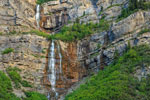 Bridal Veil Falls is located up Provo Canyon; one of Utah’s Scenic Byways. This spectacular 600 foot tall two tiered waterfall was once home to the Bridal Veil Tram and the Eagle’s Nest Lodge. In 1996 an avalanche severely damaged the tram line and the Bridal Veil Fall Tram has been closed since. Today all that remains of the commercial operation is some crumbling old concrete structures that once housed the tram equipment. The Bridal Veil Park surrounds the falls offering visitors picnic tables, grills, restrooms and the beautiful surroundings of the Provo River; one of Utah's Blue Ribbon fly fishing waters.
The Highest Point Of The Skyline Drive
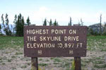 The Skyline Drive meanders its way for nearly one hundred miles along the Wasatch Plateau. The elevation of this scenic drive ranges from 9,000 to 10,897 feet which is the highest point. A large forest service sign marks this location and the views of adjacent mountain ranges and the Sanpete Valley are spectacular. On our visit we traveled up Manti Canyon to the top and then south on Skyline Drive towards Twelve Mile Canyon. The wild flowers were in full bloom providing mountain valleys filled with red, yellow, purple and white blankets of color.
Fantasy Canyon Vernal Utah
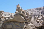 Fantasy Canyon is the official designation of an area composed of unique erosional features located about 25 miles south of Vernal, in northeastern Utah. Even though the area is somewhat small (it is not really a canyon) it contains some of the most unique geologic features in the world. The site adjoins Coyote Wash and is locally called "Hades Pit" or "Devil's Rockhouse" and is a part of "The Devils Playground" (a term coined by Earl Douglas) area which is designated on topographic maps of the area.
Miller Canyon
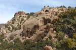 Miller Canyon is located west of the Amasa ATV Trail staging area. From the staging area travel west up the canyon and you will be treated with views of large limestone cliffs highlighted with bristolcone pines. As you make your way up the canyon you will find the first signs of mining history along with other trails that lead off to the right. Continue up the canyon and the trail will Y, one will take you south to the old mine and the trail to the north makes its way up the mountain and weaves its way through a large boulder field, aspen trees and eventfully ends. Although the map show these trails interconnecting with each other this trail appeared to end, so please don't blaze your own trail!
Provo River Parkway Trail - Canyon View Park To Vivian Park
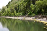 The Provo River Parkway trail begins at the Utah Lake State Park and winds its way along the Provo River then along University Avenue to the mouth of Provo Canyon. Due to the size of this trail system we decided to break it up into smaller sections. We started today's leg at the Canyon View Park near the mouth of Provo Canyon. From the park there is a large bridge that will take you across the Provo River and put you right on the trail, were you will have two options, either to head up Provo canyon or head down towards Provo.
Sinkhole Utah's West Desert
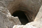 Said to have been carved by an ancient underground river the West Desert Sinkhole was discovered in 1927 by Joseph Nielson. Nielson was driving some mules on a dark night back to his camp when he strayed into the area by mistake. Nielson's horse stopped and refused to take another step. Nielson got off his horse and started walking forward when suddenly, the ground below his feet gave way tumbling into the unseen sinkhole. In desperation, he held onto the reins and his horse quickly backed up, pulling him away from the yet unseen danger.
The Wedge Overlook
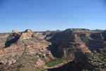 The Wedge Overlook is one of the most scenic vistas in the state. It overlooks the San Rafael river as it flows through the “Little Grand Canyon”. The San Rafael river is a combination of Ferron Creek, Cottonwood Creek, and Huntington Creek, which meet at a single point, and then continue to the Colorado River. The Wedge is a massive upheaval geological dome of which the top layers have eroded away. Further erosion by the San Rafael River has created the spectacular views that are available today. The Wedge Overlook provides restrooms, handicap access, camping (limited to designated sites) hiking and mountain biking.
Maple Canyon - Fountain Green Utah
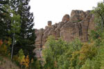 Maple Canyon is located South West of Fountain Green Utah by the small town of Freedom. This canyon is rated one of the top locations in the world for rock climbing. The reason for this is that Maple Canyon offers such diverse climbing opportunities to match any climbing skill. The rock walls are filled with thousands of imbedded cobblestones, which makes every climb in this canyon very unique. This canyon offers hundreds of established climbing routes that range from walls less then ten feet high to hundreds of feet, and for those more advanced climbers there are several large over hangs.
Utah's Fall Colors - 8 Viewing Locations
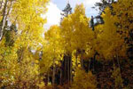 The Alpine Loop is 24 miles long and provides spectacular views of Mount Timpanogos and the Lone Peak Wilderness Area. The lush vegetation and Aspen groves will provide beautiful bright fall colors. A couple of miles after the Tibble Fork junction the road becomes very narrow and pulling trailers is prohibited. As you drop over into the Provo Canyon side take a break at Cascade Springs for a different outdoor treat of beautiful cascading waterfalls amongst the fall colors and the Provo Canyon views.
Flaming Gorge Dam
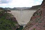 Flaming Gorge Dam is located on the Green River in northeastern Utah. Construction of the dam was completed in 1964, and full operation of the dam and reservoir began in 1967. The power plant began commercial operation in 1963. Reclamation operates the power plant located at the base of the dam, and the Western Area Power Administration (Western) markets the power. Water released from the reservoir through the power plant ranges from 800 to 4,700 cubic feet per second (cfs). The dam is a concrete arch structure with a height of 502 feet and a length of 1,285 feet.
Tabernacle Hill
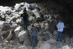 Located west of the small town of Meadow Utah is Tabernacle Hill. Thousands of years ago this old volcano erupted leaving behind miles of lava fields, craters and lava tubes. These lava fields are said to be approx 10,000 to 24,000 years old and formed while Lake Bonneville was receding. On our visit to this area we were completely fascinated by the formations that were left behind waiting to be explored. Around every corner was some new geological formation that we had never seen before. It was amazing to see the force that mother nature had on this area.