Winter Campout Vernon Reservoir
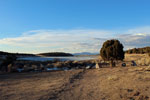 In this video we head to Vernon Reservoir for a winter camp out. The plan for this outdoor adventure was to also ice fish Vernon Reservoir. However, over the last week the temperatures reached into the fifties, so we were not sure if the ice was safe. Before heading out to check the ice, we put together a Dutch Oven Pot Roast and let it slow cook over the coals. Most of the reservoir had three to six feet of questionable ice around the shoreline. We checked the ice by the dam, and was able to find a good 10 inches of safe ice. The fishing was fast, as we hooked several trout, and two nice tiger trout within a few hours a fishing. We then headed back to camp to enjoy a nice pot roast meal and relaxed around the campfire.
Campout at the Ledgefork Campground (Video)
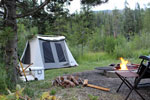 Ledgefork Campground is located just above Smith and Morehouse Reservoir on the western edge of the Uinta Mountains in northeastern Utah. The town of Oakley is just 14 miles away. Visitors enjoy fishing, canoeing and exploring the Smith and Morehouse Trail. The campground is situated within a quarter-mile of the reservoir in a scenic conifer and aspen forest at an elevation of 7,800 feet.
Ledgefork Campground
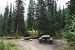 Ledgefork Campground is located just above Smith and Morehouse Reservoir on the western edge of the Uinta Mountains in northeastern Utah. The town of Oakley is just 14 miles away. Visitors enjoy fishing, canoeing and exploring the Smith and Morehouse Trail. he campground is situated within a quarter-mile of the reservoir in a scenic conifer and aspen forest at an elevation of 7,800 feet. Smith and Morehouse Creek runs through the campground. A variety of wildlife makes its home around the reservoir, including moose and deer. Summer temperatures range from 65-75 degrees in the day to 40-50 at night.
The Lace Curtain Utah
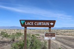 Located just southeast of Delta and northwest of Fillmore Utah, you will find a very unique formation called the Lace Curtain. This rock formation is on the north slope of Pahvant Butte, which is an old extinct volcano. The curtain formed by erosion from Lake Bonneville some 15,000 years ago. As the waves pounded the north side of Pahvant Butte, it eroded the wall, exposing the “cemented volcanic deposits”, leaving behind what appears to be a wall of melted wax.
First Outing on the Ascend 10T Kayak
 In this video, I spend the day on Deer Creek Reservoir trying out the Ascend 10T sit on top kayak for the first time. I started out at the Deer Creek State Park, and then moved further up towards Wallsburg, to avoid all the boat traffic. The fishing was slow, but I did manage a few trout. One was caught on a yellow and red spoon and the other on a trout colored spoon.
Slate Gorge – Utah Uinta Mountains
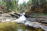 Taking a drive up the Mirror Lake Highway offers the opportunity to take in the gorgeous scenery and enjoy the many outdoor activities available along the way. One of the most popular roadside attractions is the Provo River Falls. Not far from the falls is an overlook that is just as impressive in its own unique way called the Slate Gorge.
Hill Aerospace Museum
 Before we get into this outdoor activity I have to say, I have lived in Utah my entire life, and I have driven by the Hill Air Force Base Aerospace Museum abundance of times, and not once have I stopped to visited until now. I’m actually a little embarrassed to think that this museum is so close to home, requires no entry fee, and I never taken the time to check it out. Even worse, I’m a huge WWI and WWII buff and love watching documentaries and learning about these two historical wars.
Wilson Arch
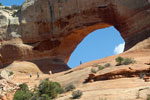 This arch can easily compete with those found in Arches National Park. While driving down US-191 on our way to Moab, we noticed many vehicles and truckers pulled off to the side of the road. At first, we thought it was a rest area, but then as we looked up into the desert landscape there was a beautiful arch. Knowing that this area is famous for its natural arch formations, we were surprised to find one so close and accessible to the road.
Four Corners Monument
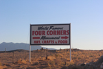 To begin this article, we want to say that the Four Corners Monument is a secluded out of the way location. The nearest town is Teec Nos Pos, AZ which is 6 miles away and the road that enters into the monument is actually in New Mexico. The nearest Utah town offering full service amenities is Bluff, Utah and it is 65 miles away from the monument. Now, because this location was part of our bucket list of must-see Utah locations, we planned on visiting the monument along with several other Southern Utah locations.
Moqui Cave Museum & Gift Shop
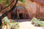 While spending the week exploring southern Utah, we were driving down US 89 just outside of Kanab. We were heading to our next destination; the 4 corners monument, when we passed this unique roadside attraction. We continued down the highway for a bit and decided to turn around to see what this “cave” was all about. The outside of the cave looks liked an ancient Native American cave dwelling. The grounds around the cave featured replicas of ancient dwellings, green grass, and different species of desert plant life.
Exploring Cedar Breaks
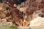 With an elevation of over 10,000 feet the Cedar Breaks National Monument offers not only the red rock beauty of southern Utah, but also the beauty of a high elevation forest. Lined along the rim of the "half-mile deep geologic amphitheater" you will discover bristlecone pines, aspens, and beautiful high mountain meadows. Our visit to the monument started in the town of Brian Head, Utah. This ski and summer resort town offers lodging, shopping, rentals, and more.
Searching for Native American Rock Art
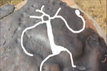 In this video I spend the day searching for Native American Rock Art on the west side of Utah Lake. As I hiked around avoiding the very large spiders, I did manage to find a few rocks that had what I believe were Native American writings. Finding the rock art was not easy with an untrained eye, but I took my time enjoying the experience and it paid off.
Utah Spiral Jetty
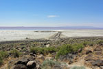 Secluded and unique is one way to describe the Spiral Jetty which is located at Rozel Point on the northeastern shore of the Great Salt Lake. Back in 1970 Robert Smithson chose this area because of its ecological and geological properties. Black basalt rocks a remnant of an ancient lava flow are scattered around this area. The jetty was constructed out of this lava rock and took a crew operating dump trucks, a tractor, and a front loader to move 6,000 tons of rock to create the jetty. The end result was a coil that is 15 feet wide and 1500 feet long. In 1972 the water levels in the lake rose and submerged the jetty until 2002 when droughts caused the lake level to decline. The sculpture has been visible ever since.
Hiking Season Preparedness
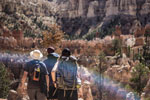 Are you physically prepared for this hiking season? If you hike or stay very active year round, then this article may not be for you. However, if you're one of those winter hibernators and the warm weather has you looking forward to the first hike of the season, then you may want to continue reading. Before we get into this article we want to first share some stats. Did you know that on average 1400 people are rescued in Utah each year? Did you know that a large percentage of these rescue operations are for hikers?