This article may include affiliate links. If you click a link and make a purchase, Utah Outdoor Activities may receive a small commission at no extra cost to you. We only recommend products or services we personally use. FTC Affiliate Disclosure.
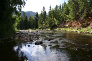
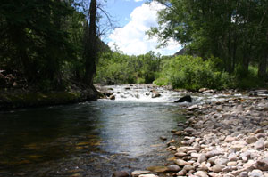
The Duchesne River and its tributaries provide miles of fly and spin fishing opportunities. The river is split into three sections, North Fork, West Fork and the Duchesne. The West Fork and the Duchesne river are considered one of Utah's blue ribbon fisheries.
The West Fork flows approx 16 miles from its head waters. The upper portion flows through the Ashley National Forest making it accessible to public access. The lower portions of West Fork to the North Fork confluence are on private property. Public access along the stream corridor through private lands has been acquired. These access points along SR-35 are marked with small brown signs, usually by a large pull out.
Due to the misdeeds of anglers over the years most of the public access to the Duchesne river has been closed. Public access from the North Fork confluence to just below the Sand Creek bridge has been acquired. This access allows fishing on approx 3.5 miles of the Duchesne river. We found this stretch of river to be very productive and had a great time. There is no public access to the Duchesne river past Hanna Utah. Please respect private property to help insure the sections that are still accessible remain open.
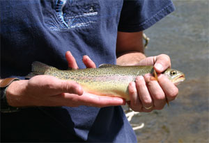
The best techniques for fishing this river system is to imitate natural foods. Natural aquatic foods include: stoneflies, caddis flies, mayflies, diptera larva, water beetles, amphibians, dace, sculpin, small trout, white fish and suckers. For spin fishing we found that silver bladed Panther Martins work well. Before fishing any river be sure to check the current regulations.
Driving Directions:
In the summer months travel from Salt Lake City via I-80 east to exit 148 Heber/Vernal. Travel on US-40 to the Park City/Kamas/Francis exit. Turn left onto SR-248 towards Kamas/Francis. Approx 11.4 miles turn right onto SR-32. Follow SR-32 through town to a four way stop. Turn Left onto SR-35 and continue over Wolf Creek Pass. Be sure to bring your camera and enjoy the many scenic pullouts that Wolf Creek Pass offers. Be on the lookout for wildlife as it is not uncommon to see Deer, Elk, Moose, and even Bears. Once over the top you will see the river off to your right.
Year around driving directions:
From Salt lake City travel via I-80 east to exit 146 Heber/Vernal US-40. Travel for approx 13 miles to Heber City. Continue on US-40 to Fruitland Utah. Once in Fruitland take a left on SR-208 towards Tabiona Utah. From SR-208 you will turn left on SR-35. Travel through Tabiona and Hanna Utah. Once past Hanna Utah you will began to see the Fisherman access locations.
We hope you enjoyed this information. For more outdoor activities, please connect with us on YouTube, Facebook and Instagram. Help us keep this site up and running by visiting our online store which features outdoor themed gifts, decor and more. Thank you for visiting and for your ongoing support!